Property Record
422 Lavender Rd, Athens, GA 30606
NEARBY LISTINGS FOR SALE OR LEASE
Property Detail
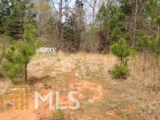
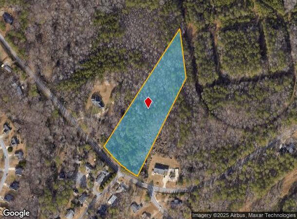
422 Lavender Rd
Athens-Clarke County, GA
Res-St-028->00-03
062-023-B
TRACT 2 - 4.379 AC - PB34/248
Residentialacreage
Clarke
X
Georgia
13059C0013E
4.38 AC
2025
Westside Athens
2025
Other Market Areas
130400
DEMOGRAPHICS near 422 Lavender Rd
1 Mile
3 Mile
5 Mile
2024 Total Population
3,610
24,765
79,706
2029 Population
3,597
25,091
81,268
Pop Growth 2024-2029
(0.36%)
+ 1.32%
+ 1.96%
Average Age
40
38
35
2024 Total Households
1,413
9,774
30,668
HH Growth 2024-2029
(0.21%)
+ 1.30%
+ 1.81%
Median Household Inc
$67,938
$59,456
$53,501
Avg Household Size
2.50
2.40
2.20
2024 Avg HH Vehicles
2.00
2.00
2.00
Median Home Value
$237,142
$249,581
$282,610
Median Year Built
1987
1985
1987
Nearby Places
Map Layers
Map Styles
 Street
 Aerial
- Restaurants
- Banks
- Shops
- Fitness
- Groceries
SALE & LEASE HISTORY
LISTING DATE
SALE/LEASE

Oct 24, 2016
For Sale
Feb 27, 2017
For Sale
Aug 01, 2019
For Sale
Nearby Properties
Address
Land Use
TOTAL SIZE
Lot Size
Zoning
Address
Land Use
TOTAL SIZE
Lot Size
Zoning
85,608 SF
63.75 AC
RM-2
Address
Land Use
TOTAL SIZE
Lot Size
Zoning
87,066 SF
36.66 AC
RM-2
Address
Land Use
TOTAL SIZE
Lot Size
Zoning
56.15 AC
G
Address
Land Use
TOTAL SIZE
Lot Size
Zoning
4,907 SF
28.35 AC
RM-2
Address
Land Use
TOTAL SIZE
Lot Size
Zoning
112,071 SF
5.27 AC
E-O
Address
Land Use
TOTAL SIZE
Lot Size
Zoning
77,919 SF
8 AC
E-I
Address
Land Use
TOTAL SIZE
Lot Size
Zoning
49.58 AC
G
Address
Land Use
TOTAL SIZE
Lot Size
Zoning
88,251 SF
8.16 AC
C-G
Address
Land Use
TOTAL SIZE
Lot Size
Zoning
58,706 SF
12.86 AC
C-G
Address
Land Use
TOTAL SIZE
Lot Size
Zoning
26.86 AC
G
Address
Land Use
TOTAL SIZE
Lot Size
Zoning
3,223 SF
17.81 AC
RS-5
Address
Land Use
TOTAL SIZE
Lot Size
Zoning
19.21 AC
G
Address
Land Use
TOTAL SIZE
Lot Size
Zoning
4,148 SF
7.04 AC
RM-1
Address
Land Use
TOTAL SIZE
Lot Size
Zoning
664,513 SF
84.46 AC
I
Address
Land Use
TOTAL SIZE
Lot Size
Zoning
44,563 SF
18.32 AC
C-G
Address
Land Use
TOTAL SIZE
Lot Size
Zoning
39.94 AC
C-O
Address
Land Use
TOTAL SIZE
Lot Size
Zoning
121,382 SF
16.01 AC
C-G
Address
Land Use
TOTAL SIZE
Lot Size
Zoning
2,100 SF
7.14 AC
RM-1
Address
Land Use
TOTAL SIZE
Lot Size
Zoning
31,067 SF
5.05 AC
C-O
Address
Land Use
TOTAL SIZE
Lot Size
Zoning
1,378 SF
21.13 AC
RM-1
Address
Land Use
TOTAL SIZE
Lot Size
Zoning
62,856 SF
37 AC
I
Address
Land Use
TOTAL SIZE
Lot Size
Zoning
42,548 SF
5.34 AC
C-O
Address
Land Use
TOTAL SIZE
Lot Size
Zoning
50,400 SF
3.29 AC
C-G
Address
Land Use
TOTAL SIZE
Lot Size
Zoning
79,875 SF
7.37 AC
C-G
Address
Land Use
TOTAL SIZE
Lot Size
Zoning
Address
Land Use
TOTAL SIZE
Lot Size
Zoning
23.30 AC
P
Address
Land Use
TOTAL SIZE
Lot Size
Zoning
50,901 SF
16.84 AC
G
Address
Land Use
TOTAL SIZE
Lot Size
Zoning
66.26 AC
RM-2 (PD)
Address
Land Use
TOTAL SIZE
Lot Size
Zoning
63,207 SF
5.60 AC
C-N
Address
Land Use
TOTAL SIZE
Lot Size
Zoning
15,145 SF
3.28 AC
C-N
The World's #1 Commercial Real Estate Marketplace
Connect with us
© 2025 CoStar Group
The information above has been obtained from sources believed reliable. While we do not doubt its accuracy we have not verified it and make no guarantee, warranty or representation about it. It is your responsibility to independently confirm its accuracy and completeness. Any projections, opinions, assumptions, or estimates used are for example only and do not represent the current or future performance of the property. The value of this transaction to you depends on tax and other factors which should be evaluated by your tax, financial, and legal advisors. You and your advisors should conduct a careful, independent investigation of the property to determine to your satisfaction the suitability of the property for your needs.